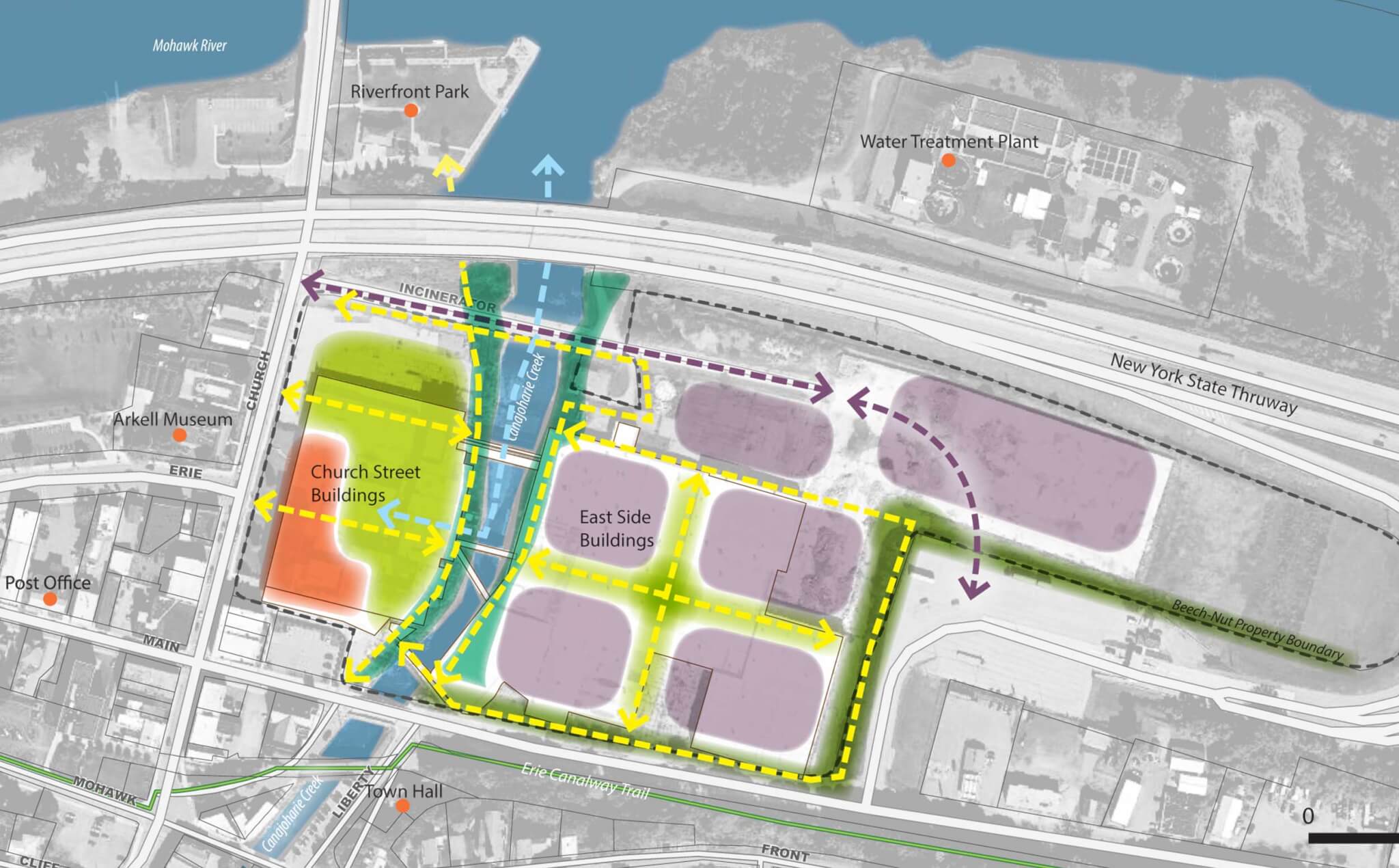
The figure above illustrates a site concept plan that integrates a mix of uses and multi-modal connections reflecting community goals and the surrounding land use context. These future use zones described in more detail below can help guide redevelopment planning, phasing and implementation.
Please note: this diagram suggests approximate placement and scale of future use and connections. Built form and connections to be determined by master plan.
Redevelopment Planning
Community goals for redevelopment planning, phasing and implementation.
Downtown Redevelopment
Pursue adaptive reuse or new construction to complement the downtown historic district.
Support a mix of commercial uses and community-oriented facilities for education and innovation.
Provide accessible buildings storefronts and sidewalks similar to size and style of downtown.
Provide parking on street or behind buildings to supplement existing downtown parking.
Consider retaining or incorporating the historic “green” along Church Street as an active open space for the Village.
Mid-Size Redevelopment
Accommodate larger buildings in a campus-like setting.
Support a mix of uses that need larger structures, such as indoor recreation, light industry and urban agriculture.
Provide public access to key features, such as the creek, open spaces and views from Main Street gateway.
Consider parking areas in rear of buildings to integrate new development with look and feel of downtown.
Flexible Green Space
Provide a variety of high quality, connected public spaces and pedestrian-friendly development.
Create public spaces such as informal green areas, small playgrounds, formal squares, market pavilion or recreational fields for people to gather, interact, and play.
Connect to Mohawk River Riverfront Park and Erie Canalway Trail.
Evaluate potential for boat access, docking and marina facilities close to downtown; consider boating access alternatives along lower Canajoharie Creek and options aligned with the former Erie Canal channel.
Gateway Corridor
Provide a welcoming Main Street entry corridor from the Thruway to the Village downtown area.
Support a mix of commercial uses and community-oriented facilities for education and innovation.
Canajoharie Creek
Restore the Canajoharie Creek corridor to increase safe access and flood resilience.
Provide safe access and views to Canajoharie Creek.
Consider opportunities to integrate plantings and trees along streambank to improve water quality and reduce flooding.
Industrial Thoroughfare
Redirect truck and freight traffic away from downtown to improve quality of life downtown and make more walk-able.
Explore an alternate truck route through the north portion of the site.
Pedestrian & Bike Paths
Link open spaces and buildings to ensure the site is pedestrian-oriented and accessible to and from the Village.
Connect public spaces and key features with sidewalks and paved paths. Consider paths at different widths to accommodate pedestrians and/or bicyclists.
Connect on-site paths with the Erie Canalway and existing downtown.
Waterway
Evaluate potential for boat access, docking and marina facilities close to downtown.
Consider boating access alternatives along lower Canajoharie Creek and options aligned with the former Erie Canal channel.
Unlimited Potential
Few constraints exist for the redevelopment of the former Beech-Nut facility. The site has the potential for a multitude of uses including commercial use, light industrial, agricultural production, renewable energy facilities, educational or institutional campuses, residential housing development, entertainment venues, medical or elder care facilities, and hospitality.